
i-Boating:UK/Ireland:Marine
by Gps Nautical Charts
Version 100+ 💾 25 Mb
📅 Updated Eligible if bought after 7/2/2016.
Learn
GPU accelerated marine vector maps with Voice Prompts. Never get lost again!!

Features i-Boating:UK/Ireland:Marine
This App offers access to marine vector covering UK/Ireland waters (derived from UKHO data).
First marine GPS app to have route assistance with Voice Prompts for marine navigation.
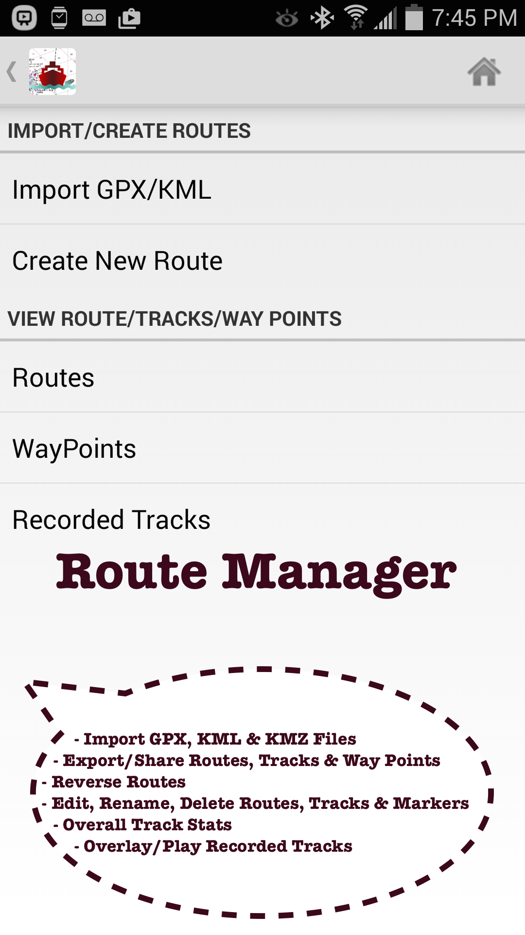
You can create new boating routes or import existing GPX/KML routes.
It supports Nautical Charts course up orientation.
Includes Tide & Currents prediction.►FEATURES√ Beautiful and detailed Hardware/GPU accelerated vector charts (text stays upright on rotation)√ Long press to query the details of Marine object (Buoy, Lights, Obstruction etc).√ Customizable depth(Ft/Fathom/Meter) and distance units (km/mi/NM)√ Customizable Shallow Depth.√ Record tracks, Autofollow with real-time track overlay & predicted path vector.√ Voice Prompts for marine navigation (requires GPS )√ 1ft / 3ft depth contour maps for anglers for selected lake maps.√ Supports GPX/KML for boating route editing/import.√ Tide & Currents prediction.√ Seamless chart quilting of marine charts√ Enter or import Waypoints.► MAPSThe maps include coverage of coast of UK & Ireland (derived from UKHO data).►ROUTE MANAGEMENT / TRIP PLANNING√ Create New Route/Edit Existing Routes√ Move Points√ Add points to an existing route leg√ Delete / Rename points√ Import GPX, KML & KMZ files√ Plot/Edit Routes √ Enter Waypoints√ Share/Export Routes, Tracks & Markers√ Reverse Routes►GPS FEATURES√ Auto Follow* Real Time Track Overlay* Predicted Path Vector* Course Up (Text stays upright)* Speed & Heading√ Route Assistance With Voice Prompts* Prompts when approaching a boating route marker* Continous distance and ETA updates* Alerts when sailing/boating off route* Alerts when boating in wrong direction√ Record Tracks►NMEA Instrumentats√ AIS & GPS(NMEA over TCP/UDP)√ Wind direction & Speed,Sonar depth,Water temperature► Available Chart folios√ BRISTOL CHANNEL & SOUTH IRELAND√ ENGLAND S COAST & SCILLIES√ IRELAND W C-KENMARE R-FORELAND√ IRISH SEA√ N&E SCOTLAND-LEWIS-FORTH-N ISLES√ NORTH SEA-FORTH-THAMES ENTRANCE√ SCOTLAND KINTYRE-LOCH BROOM√ THAMES-MEDWAY & APPROACHES►TIDE & CURRENTS* For US, Canada, UK, Germany & New Zealand* High/Low Tides* Tidal Current Prediction* Active Current Stations► SHARING* Share tracks/routes/markers on Facebook & Twitter* Export tracks/routes/markers as compressed GPX files.►Custom Base Map√ Satellite/Aerial Imagery, Street Maps etc.►Online Chart Viewerhttp://fishing-app.gpsnauticalcharts.com/i-boating-fishing-web-app/fishing-marine-charts-navigation.html#12.21/51.4638/0.4629►Custom Base Map√ Satellite/Aerial Imagery, Street Maps etc.► Advanced NMEA Instrumentation√AIS over TCP/UDP√Wind speed, direction, temperature, depth, GPS over NMEA► Adjust depth level (Depth offset)
Social Features
Connect and share with friends and the community.
Weather Features
Get accurate weather forecasts and real-time updates.
Fitness Tracking
Track your workouts and monitor your health metrics.
See the i-Boating:UK/Ireland:Marine in Action

What Our Users Say
Don't just take our word for it. Here's what our users have to say about our Android app.
"Easy simple and cheap"
Ian Stothers
"Good"
doyle howth
"Easy to use and we'll detailed. Update reminders a bit of a pain"
James curtis
"Brilliant....everything is easy to manage and understand"
Michael Beer
"This app has a more accurate than the other one i have. I can turn off wifi and mobile data and still know the track im on. Gr8! Better value for money than other ones"
Caithimhjoe 21
"Impressive"
A Google user
"Works well, and most importantly it accurate!!"
richard taylor
"Very (!) fluent scroll and zoom, unlike Navionics and Transas. An instant favourite."
J Rajaste
Get the App Today
Available for Android 8.0 and above